NATIONAL HARBOR, Md.—The proliferation of commercial satellites is changing the character of war, a panel of military experts said at AFA’s Air, Space & Cyber Conference on Sept. 18.
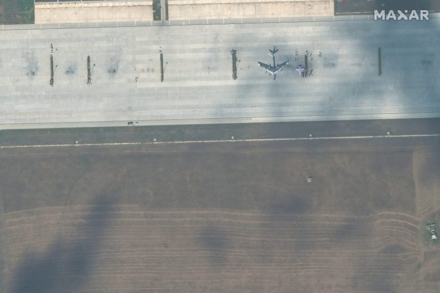
In Ukraine, Russia has been able to use its own satellite capabilities and has been bolstered by readily available commercial imagery.
“I think both Ukrainians and the Russians on the ground are learning some painful lessons about what I’m going to call the ubiquity of sensing and targeting,” said David A. Ochmanek, a researcher at the RAND Corporation and a former deputy assistant secretary of defense for force development.
“Now, there are ways to counter space-based sensors,” Ochmanek added. “There are ways to counter airborne sensors at all levels. But it seems to me, on this battlefield at least, that if you want to survive, you’ve got to be dispersed, you’ve got to be mobile, you’ve got to be hidden.”
While commercial satellite imagery was once the domain of a few nations with high-end space capabilities, journalists, open-source intelligence trackers on social media, and adversaries can now all access it.
“One of the issues that was raised by the senior officials in the Ministry of Defense and Air Force back when I visited Kyiv was, ‘Can you help us please figure out a way to deny commercial satellite coverage that the Russians are using to see what we’re doing here in Ukraine?’ So, yeah, sensing has become ubiquitous,” said retired Lt. Gen. David A. Deptula, dean of the Mitchell Institute for Aerospace Studies and a former deputy chief of staff for intelligence, surveillance, and reconnaissance in the Air Force. “We see that today unfolding in that battle space, and it’s going to be with us everywhere else.”
Coupled with the proliferation of guided munitions—and the ability to use unguided munitions more accurately—that imagery is putting more and more targets at risk.
“Bottom line, if there’s anything bigger than a bread box that you’re interested in, it’s going to be targeted,” Deptula added.
The war in Ukraine has also featured the use of drones—including quadcopters, first-person view one-way attack drones, and Iranian-designed Shaheds—throughout the battlefield. Some of the most high-profile uses have seen Ukraine and Russia carry out deep strikes with unmanned aerial vehicles. But there are other uses as well, such as loitering over infantry units and for artillery spotting.
The U.S. military has long been the world’s foremost operator of ISR drones, but it is also turning to commercial satellite imagery to augment those aircraft.
The Space Force has used its Tactical Surveillance, Reconnaissance, and Tracking (TacSRT) program, which gets tactical information from commercial providers, to support combatant commanders. Chief of Space Operations Gen. B. Chance Saltzman said the U.S. has been able to use such capabilities to provide “overwatch” of U.S. troops withdrawing from Niger over the past few months.
“That used to be done by an MQ-9 or something like that, and they were able to take this commercial satellite imagery and then put some intelligence behind it and get it down to the operators on the ground in an hour and a half,” added Gen. James B. Hecker, commander of U.S. Air Forces in Europe-Air Forces Africa (USAFE-AFA), during a roundtable with reporters. “That’s not as good as real-time as with an MQ-9 you would have, but it’s better than nothing.”
The proliferation of satellite imagery has not only been employed as a military tool but as a diplomatic one. In the run-up to Russia’s full-scale invasion of Ukraine in February 2022, the U.S. government declassified intelligence that Russia was planning an invasion—the most striking example in the prelude to the war was imagery showing Russian troops near the border, a sight hard for the Kremlin to brush off.
“I could step back to the couple months prior and then the initial invasion … don’t forget the importance of information sharing and what we did at the beginning to bring together the team that was able to facilitate at least the deterrence on the Eastern flank for NATO,” said retired Gen. Jeffrey L. Harrigian, the commander of USAFE-AFA at the time of the Russian invasion and Hecker’s predecessor. “The way we were able to share information at speed to the right people from the strategic to the tactical level, build trust and confidence across the force—and without that, you’re never going to be able to win.”